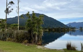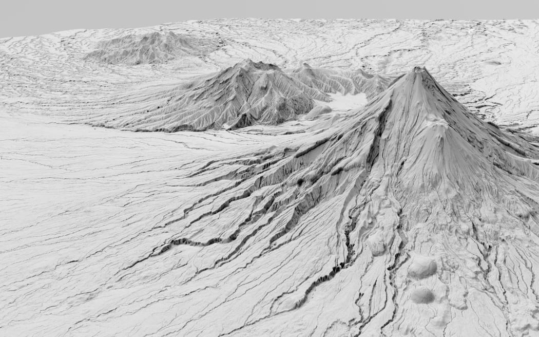
A high-definition aerial laser survey of Taranaki, funded by the Provincial Growth Fund, has just been completed, creating an exact 3D map of the region's entire surface. Photo: Supplied / LINZ
A ground-breaking aerial laser survey has enabled the creation of an exact 3D map of Taranaki for the first time.
The data will be used to generate high-definition 3D maps and models that will have a wide range of uses in environmental management and planning, managing natural hazards, planning of facilities, services and infrastructure and tracking changes to the coastline and river channels.
Taranaki Regional Council has worked with Toitū Te Whenua Land Information New Zealand (LINZ) on the LiDAR (Light Detection and Ranging) survey to gather land-surface and elevation data.
"It's fantastic to see the completion of the project and now we can start using that invaluable data to care for our environment," said council director-operations Daniel Harrison.
"There are myriad applications where we and our partners can use this data and it is available to the public as well. The level of detail is incredible and it will be a really useful tool for our staff."
Harrison said the LiDAR information would help the district council's land-use planning and provision of services, while the University of Auckland was interested in surveys of Taranaki Maunga's volcanic cone.
"We're expecting surveyors, engineers, construction companies, farm planners and others to find the maps and models useful as well."
The survey involved a small twin-engine plane flying over Taranaki in 2021 using LiDAR laser scanning to map the terrain. The laser beams were not visible and didn't affect electronics and the plane's high altitude meant the public and livestock were not disturbed.
LINZ technical leader imagery and elevation, Bjorn Johns, said the data set had been two years in the making.
"It's exciting that we now have accurate elevation information right down to the property scale for the entire Taranaki region. The new digital elevation data provides certainty to councils and landowners and ensures their terrain modelling is as accurate as possible.
"The LiDAR data allows for improved 3D visualisation of the land that proves valuable context for planning and mapping, and we make the data available to anyone via the LINZ Data Service.
"As new datasets across the country are completed and contributed to the LINZ National Elevation Programme, the amount of national coverage increases, giving us the best possible picture of New Zealand."
Funding for the $1m project came from the Provincial Growth Fund (PGF), via LINZ, with contributions from the region's councils and the University of Auckland.
Taranaki Regional Council was one of 10 regional councils nation-wide given funding from the PGF for regional scale LiDAR mapping projects.
LiDAR surveys can be used for:
- Assessing vegetation cover and habitat quality.
- Getting a more accurate picture of erosion.
- Allowing better modelling of the effects of floods and droughts.
- Monitoring the changes in coastal dunes.
- Providing a clearer picture of the steepness of hill country land.
- Allowing sharper definition of sites of cultural significance.
- Monitoring natural hazards.
The PGF is one of six funds administered by Kānoa - Regional Economic Development & Investment Unit within the Ministry of Business, Innovation and Employment. The PGF is now fully allocated.